The Land of Egypt
This map is available as a high resolution digital download with detailed instructions. You must bring the file to an Office Depot or similar store for easy color print and lamination. For personal, church or classroom use only.
Exodus 10:13 - "And Moses stretched forth his rod over the land of Egypt, and the LORD brought an east wind upon the land all that day, and all that night; and when it was morning, the east wind brought the locusts."
FOLLOW THE MAP
The Land of Egypt for Little Kids

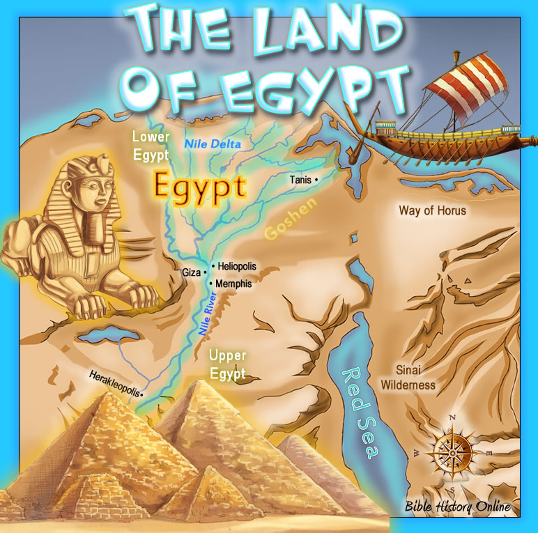
This map shows some of the key places and topography of the
land of Egypt during ancient times!
In Biblical times, Egypt was a very powerful and wealthy nation. They were able
to build the huge Pyramids of Giza because they had many slaves. Pharaoh, the
king of Egypt, enslaved the Hebrews until God used Moses to lead them out of the
country and across the Red Sea. Many important things happened in Egypt, and the
nation was talked about in almost half of the books of the Bible!
The land of Egypt was very hot and dry because it was in the middle of two
different deserts! People were only able to live there because the Nile River
provided them with water and fertile land, especially in Lower Egypt where the
Nile Delta is. The Nile is extremely long and is very unique for flowing north
because most rivers flow south!
Ancient Egypt is an interesting place and it is good to study it so that we have
a better understanding of God's Word and what it was like during Biblical times.
Click here to listen if the above player does not work.
The Land of Egypt for Big Kids
 Egypt
in Bible History. God is in control of rulers and nations, and the land of
Egypt played an important role in Biblical history. In the earliest of times
Egypt was wealthy and powerful beyond imagination. The pyramids of Giza are just
a glimpse of the ancient past of this civilization. Yet in the Bible Egypt is
symbolized as a type of the world, a place of bondage and slavery. The Pharaoh
is a type of Satan who will not let God's people go, and his taskmasters are
continually tormenting God's people. When
Jesus died and rose again the Bible says he set the captives free, and the power
of Satan has been defeated. The cry of Jesus on the cross "it is finished" is a
victory cry, and a believer in Christ has escaped the bondage of slavery in sin,
and is entered into a new place, the promise land, the place of freedom and the
place of God. Egypt was a real place in the Bible, the founder was Mizraim, the
grandson of Noah, and son of Ham who was the second
son of Noah. Mizraim's descendants occupied the land known as
ancient Egypt.
Egypt
in Bible History. God is in control of rulers and nations, and the land of
Egypt played an important role in Biblical history. In the earliest of times
Egypt was wealthy and powerful beyond imagination. The pyramids of Giza are just
a glimpse of the ancient past of this civilization. Yet in the Bible Egypt is
symbolized as a type of the world, a place of bondage and slavery. The Pharaoh
is a type of Satan who will not let God's people go, and his taskmasters are
continually tormenting God's people. When
Jesus died and rose again the Bible says he set the captives free, and the power
of Satan has been defeated. The cry of Jesus on the cross "it is finished" is a
victory cry, and a believer in Christ has escaped the bondage of slavery in sin,
and is entered into a new place, the promise land, the place of freedom and the
place of God. Egypt was a real place in the Bible, the founder was Mizraim, the
grandson of Noah, and son of Ham who was the second
son of Noah. Mizraim's descendants occupied the land known as
ancient Egypt.
The Land of Egypt. In ancient times the land of Egypt was located in the northeast corner of the continent of Africa. Egypt began at the Mediterranean Sea in the north and extended all the way to the cataracts of Assouan on the Nile River in the south, as Ezekiel said "from the tower of Syene even unto the border of Ethiopia" (Ezekiel 29:10). To the east was the Arabian desert and the Red Sea, and to the west was the great Sahara desert. The area of Egypt was about 600 miles long and 300 miles across (186,000 square miles). The main emphasis of Egypt is always the Nile River, which flowed from southern Africa northward for over 4000 miles, all the way to the Mediterranean Sea where it formed a triangle of rivers called the Nile Delta, and the waters emptied into the Mediterranean in seven channels. The banks of the Nile River provides one of the most fruitful areas on the entire planet, and the Nile Delta was the most fertile portion of Egypt.
Upper Egypt. The land of Upper Egypt was in the southern portion of Egypt, and it was really just the narrow winding valley of the Nile River. The limestone and sandstone banks of the river were not very high except for a few peaks. There were no great cities along this section of the Nile River, but there have been remarkable discoveries of ancient monuments.
Lower Egypt. in ancient times Lower Egypt was in the northern portion of Egypt, it was a huge fertile plain that began at the Nile Delta and extended to the area on the Nile River below Memphis. The great seaports are Alexandria, Rosetta, and Damietta.
The Nile River. The Nile River was the lifeblood of Egypt. The Egyptians depended upon the Nile River for everything. There was hardly ever any rain in the land, and therefore the main source of water was always the Nile River. Everybody always lived close to the river, because the further away anyone would journey, the more barren it would become. Every year the Nile River would overflow its banks, and he would leave a very rich layer of silt. Once the river receded back farmers would plant their crops in the fertile soil which would guarantee a good harvest. The river was a major part of everyone's life, even the Pharaoh of Egypt who would pray to his gods at the banks of the river.
The Land of Ham. The second son of Noah was Ham. His son Mizraim and descendants occupied the land we know of as Egypt.
The Pyramids of Giza. The great Pyramids at Giza were built along the western bank of the Nile River. The largest of the Giza pyramids is that Great Pyramid of Khufu, which contains around 2 million stones, each one weighing around 2 1/2 tons. According to many scholars the Pyramids of Giza were built around the year 2650 BC.
The study of Egypt is very important in the study of the Bible, let's pray:
Dear Jesus, we thank you for your word which declares that Egypt was a type of the world that is slavery, and our new life in Christ is freedom. Pharaoh held your people in bondage and you set your people free. We love you. In Jesus name? Amen!
![]()
The Land of Egypt for Little Kids

Map of the Land of Egypt in Bible Times for Bible Study
Kid's Bible Maps
Bible
History Online
The Geography of the Bible
© Bible History Online (https://bible-history.com)
Made by Network Local